測量(Surveying)
コースで学ぶ内容
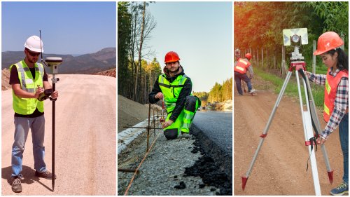
測量・調査技師を目指す方向けのコースです。データ収集、データ照会、測量設計・製図、地図製作及び地籍地図や計画のアシスタントをするための知識、及びスキルを学びます。
測量と空間情報のスキルは、都市計画、土木建設、鉱業、工学、健康、農業、防衛など、さまざまな産業で必要とされており、オーストラリアのTAFEでは、シドニーもしくは西オーストラリア州のパースで学ぶことができます。
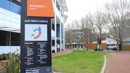
下記は、パースのTAFE WA - North Metropolitan TAFE East Perth(イーストパース)キャンパスで開講中のSurveying関連コース詳細です。
Certificate III in Surveying and Spatial Information Services(6ヶ月)
初心者レベルから基本的な測量機器を操作できるようになるためのコースです。測量アシスタントなどの職務を想定した基礎コースです。コースでは、基本的な地図の作成、読み取り、解釈、測量データの収集、基本的な測量計画の作成、基本的な測量計算を行うスキルを身につけます。また、職場の安全や現場で成功するために必要な条件についても学びます。
【入学日】(年2回)
2025年2月3日、7月21日
| コア科目例 |
|---|
| Prepare to work safely in the construction industry 建設業で安全に働くための心構え |
| Produce basic maps 基本的な地図を作成する |
| Collect basic surveying data 基本的な測量データを収集する |
| Produce basic plans of survey 基本的な測量計画の作成 |
| Perform simple surveying and spatial computations 簡単な測量と空間計算ができる |
| Operate application software packages アプリケーションソフトウェアパッケージの操作 |
| 選択科目例 |
|---|
| Read and interpret maps 地図の読み取りと解釈 |
| Provide field support services for surveying and spatial projects 測量と空間プロジェクトのフィールドサポートサービス |
| Visually interpret image data 画像データの視覚的解釈 |
| Provide First Aid 応急処置を行う |
| Apply mathematical techniques in a manufacturing engineering or related environment 製造エンジニアリングまたは関連環境での数学的手法の適用 |
※科目は産業界と協議の上で選定されており、学校やキャンパス、時期などで変わる場合があります。
Certificate IV in Surveying and Spatial Information Services(Certificate IIIと合わせて1年)
測量技師としての知識をさらに磨き、測量技術およびソフトウェアを使用して電子データを取得、処理、および表示する方法を学びます。コースでは、コンピュータ支援図面(CAD)や測量計画を作成するための測量機器を使用し、地理情報システム(GIS)データの準備なども行います。産業界と密接な関係にある専門家講師から学ぶことで、最新の業界慣行を反映したトレーニングが受けられます。
【入学日】(年2回)
2025年2月3日、7月21日
コースはコア3科目と選択12科目で構成されています。
| コア科目例 |
|---|
| Perform simple surveying and spatial computations 簡単な測量と空間計算の実行 |
| Collect spatial data using GNSS GNSSを利用した空間データの収集 |
| Operate spatial software applications 空間ソフトウェアアプリケーションの操作 |
| 選択科目例 |
|---|
| Read and interpret maps 地図の読み取りと解釈 |
| Produce basic maps 基本的な地図の作成 |
| Produce basic plans of surveys 基本的な測量図の作成 |
| Store and retrieve spatial data 空間データの保存と取り出し |
| Operate surveying equipment 測量機器の操作 |
| Perform surveying computations 測量の計算を実行する |
| Produce computer-aided drawings コンピュータ支援図面の作成 |
| Prepare and present GIS data GISデータの作成と提示 |
| Design and produce maps 地図の設計と作成 |
| Collect spatial data using a total station トータルステーションを使用した空間データの収集 |
| Set out site and building works サイトや建築物のセットアップ |
| Develop spreadsheets for spatial data 空間データ用のスプレッドシートを作成する |
※科目は産業界と協議の上で選定されており、学校やキャンパス、時期などで変わる場合があります。
※コース入学には、Certificate III in Surveying and Spatial Information Servicesを修了している必要があります。
Diploma of Surveying(Cerificate III、IVと合わせて2年)
測量の知識と経験をさらに広げるため、測地測量の実施方法と計算の実行方法など、測地測量に重点を置いたコースです。基本的な工学的構造の設計や空間データ収集の計画方法など、業界特有のスキルも身に付けます。土地管理のための地図の作成、鉱山図面の作成、雨水システムの設置方法など、多くの選択科目から選ぶことができます。コースでは、高度な全地球衛星測位システム(GNSS)データ収集と測量の実施方法、エンジニアリング図面の作成、および高度な測量計算の実行方法を学ぶことによって、スキルを向上させます。道路設計など、より複雑なエンジニアリング調査を行うための高度な測量機器やソフトウェアの操作方法についても学習します。
【入学日】(年2回)
2025年2月3日、7月21日
コースは下記のコア8科目と選択8科目で構成されています。
| コア科目例 |
|---|
| Conduct GNSS surveys GNSS測量の実施 |
| Conduct engineering surveys エンジニアリング測量の実施 |
| Perform complex surveying computations 複雑な測量計算を行う |
| Perform geodetic surveying computations 測地学的な計算を行う |
| Conduct precision surveys 精密測量を行う |
| Conduct geodetic surveys 測地学的測量を行う |
| Survey subsurface utility information 地下のユーティリティ情報の調査 |
| Design basic engineering structures 基本的な工学的構造物の設計 |
| 選択科目例 |
|---|
| Produce maps for land management purposes 土地管理のための地図を作成する |
| Develop a spatial data collection plan 空間データ収集計画の策定 |
| Capture new spatial data 新しい空間データの取得 |
| Set out roads and stormwater systems 道路や雨水システムの設定 |
| Develop spreadsheets for spatial data 空間データ用のスプレッドシートを作成する |
| Conduct photogrammetric mapping 写真測量による地図作成 |
| Conduct open pit mine surveys 露天掘り(鉱石の採掘手法の一つ)調査の実施 |
| Produce mine drawings 鉱山図面の作成 |
※科目は産業界と協議の上で選定されており、学校やキャンパス、時期などで変わる場合があります。
※Diplomaコース入学には、Certificate IV in Surveying and Spatial Information Servicesコースを修了している必要があります
Advanced Diploma of Surveying(Cerificate III、IV、Diplomaと合わせて3年)
複雑な工学構造物、道路、鉄道、地上および地下の採掘作業に関する空間データの収集および分析方法を学び、鉱業や土木建設などの分野で高度に専門的な測量業務を行うスキルを身につけます。コースでは、全地球測位システム(GPS)を含む高度な測量機器とソフトウェアの操作、およびコンピューター支援エンジニアリング設計と鉱山計画を作成するための測量データの処理について学習します。高度な全地球衛星測位システム(GNSS)コントロール調査や複雑なエンジニアリングセットアウト調査を実施するためのプロセス、リスク管理、エンジニアリング構造のモニタリングなどのスキルも習得します。
【入学日】(年2回)
2025年2月3日、7月21日
コースは下記のコア2科目と選択7科目で構成されています。
| コア科目例 |
|---|
| Manage project risk プロジェクトリスクの管理 |
| Conduct advanced GNSS control surveys 高度なGNSS制御測量の実施 |
| 選択科目例 |
|---|
| Conduct open pit mine surveys 露天掘りの鉱山調査の実施 |
| Produce mine drawings 鉱山図面の作成 |
| Conduct underground mine surveys 地下鉱山の調査を行う |
| Conduct mining geology project research 鉱山地質プロジェクト調査 |
| Conduct complex engineering set-out surveys 複雑なエンジニアリングセットアウト調査 |
| Monitor engineering structures エンジニアリング構造物の監視 |
| Compile mine survey plans 鉱山調査計画の作成 |
※科目は産業界と協議の上で選定されており、学校やキャンパス、時期などで変わる場合があります。
※Advanced Diplomaコース入学には、Diploma of Surveyingコースを修了している必要があります
英語力はどれぐらい必要?
IELTS Academic 6.0(各バンド5.0以上)か同等TAFE WAのSurveying関連コースに直接入学するには
IELTS 6.0(アカデミックモジュールで各バンド5.0以上)または
TOEFL iBT 60(各バンド15以上)または
英検1級 または
これらと同等レベルの英語力証明が必要です。
英語力が足りない場合はどうすればいい?
TAFE WAが提携する英語学校とセットにした留学プランがあります。まず、はじめに英語コースに通い、指定のコースを修了することで、IELTSやTOEFLの提出が免除され、そのまま専門コースに進学できます。その際、英語コースにどれだけ通えばいいか?は、個々の英語力により異なります。まずは日本でIELTS Academic、または、TOEFL iBTのどちらかを受けられた後、その結果をこちらからお知らせください。

専門学校で取得できる資格
オーストラリアの専門学校では、コース期間(内容)に応じて、Certificate、Diploma、Advanced Diploma などの資格が得られます。これらの資格は、その教育制度の違いから、日本で相当する資格がありません。しかしながら、Diploma(ディプロマ)レベルの場合、コースによっては取得に 2年を費やすものや、大学での単位 1年分に相当する場合があることなどから考えると、準学士に相当するとも言われています。キャリアアップのために専門学校をお考えの方には、Diploma レベル以上の取得を目指すのが良いでしょう。
専門学校から大学進学へのステップ
TAFEやカレッジで Diploma(ディプロマ)を取得した場合、各教育機関が提携している大学の関連コースへ進学または編入が認められる場合があります。(コースによる異なりますので、詳細はぜひお問合せください)
こんな仕事 & キャリアに役立ちます
鉱山およびエンジニアリング測量技師測量アシスタント
都市プランナーやそのアシスタント ほか

コースを開講している学校一覧
*授業料は 1セメスタ(6ヶ月)あたりの金額となります
| 都市 | 学校 | コース | 期間 | 授業料* |
|---|---|---|---|---|
| シドニー | TAFE NSW - テイフ・ニューサウスウェールズ | Surveying | 1年半 | 13304ドル |
| Surveying and Spatial Information Services | 6ヶ月 | 13700ドル | ||
| パース | TAFE WA - North Metropolitan TAFE - テイフ・西オーストラリア・ノース・メトロポリタン・テイフ | Surveying | 2年〜3年 | 7900ドル |
| Surveying and Spatial Information Services | 6ヶ月〜1年 | 7900ドル |
サイトのご利用について
当サイト記載の情報の正確性には万全を期しておりますが、当社はそれらの情報内容に関し、一切の責任を負いかねますのでご了承ください。また、情報は予告なしに変更となる場合がございますので、随時ご確認ください。